

Made in Northern Saskatchewan
Complete wildfire incident management, from before the first call to the reclamation afterwards.
Firecache handles every role on every fire: dispatch and initial attack, the incident map, crews, machines, and aircraft, the radio, notices, and evacuation plans, the dailies, crew time, invoicing, and payment, and the reclamation plan once the fire is out. Built by firefighters, and it works with no signal.
A short evaluation agreement comes first. It takes a minute.
- Every position on the fire
- Works with no signal
- English and French
- Hosted where you choose
- 06:02Daily started · Adam Smith · D6 dozer
- 06:14Truck FC-LR-T03 signed out · condition photos
- 06:40Delta crew on the hand line · tracked live
- 07:41Medical call on Command 1 · alert suggested
- 07:44Hazard reported · danger tree at KM 4
- 08:10Helicopter 360 checked in · next in 30:00
- 08:32Supply order on the road · crew shack and generator
- 09:05Daily #14730 verified · Dana Whitford
- 09:20Hose lay proposed · accepted by Command
- 10:02Stock count done · La Ronge · 2 items not found
Simple enough for anyone to pick up and figure out, no college degree needed. Powerful enough to handle every part of something as serious as an out-of-control wildfire.
Built by firefighters
We’ve been on the line too.
We built Firecache to fix the problems we kept running into on the fire, the same ones every crew and every base deals with: less paperwork, fewer mistakes, less chasing, and less money lost. It’s simple, it works without signal, and it fits the way you already work.
Paperwork that eats the day
Slips filled in by hand, retyped into spreadsheets, and chased for signatures.
The daily is filled out once on any device and looks just like the paper form. It moves from head office to the supervisor to the Time Unit on its own, and every signature is kept.
Mistakes found too late
Hours that don’t add up, missed meal breaks, and the wrong rate.
Hours, breaks, and rates are checked as they’re entered, so problems get fixed before anyone signs, not weeks later at payment.
Gear that walks away
Pumps, hose, and saws signed out on a clipboard, then missing at demob.
Every item gets a QR label, and signing it out takes one scan. Overdue gear is flagged on its own, and nobody demobs with something still signed out.
Money that slips through
Overpayments, double billing, and invoices nobody can trace.
Approved dailies are priced straight from the rate schedule, and a permanent record shows who changed what and when.
How a daily moves
One daily, from the cab to payment.
Powerful enough to run a fire season and simple enough to pick up in minutes, with no training: big, clear buttons, high-contrast colours, and plain language.
Sample data
- Start
- 06:00
- End
- 19:30
- Meal break
- 0.5 h
- Worked
- 13.0 h
- Adam SmithOperator, Adam & Co ContractingSigned
- Adam & Co OfficeContractor head officeReceived
- Dana WhitfordIncident commander, fire 017904Pending
- Shauna PelletierTime UnitNot started
Step 1 of 4
The operator fills it out in the cab
It looks just like the paper form, and the operator signs right on the screen. With no signal, it waits on the device and sends itself later.
Every feature
Everyone on the fire is on the same page
From the first call to the reclamation plan, and from the operator’s phone to the Time Unit. One app for every role, and everyone sees what’s waiting on them.
Every position on the fire: all 35, each with its own start screen
A wildfire run under the incident command system has 35 jobs, from the incident commander to the fire line medic. Each one opens on what that job needs and nothing it doesn’t, and the plan, the map, the radio, the dailies, the gear, and the money are the same records, so nobody types anything twice. Add the positions your agency uses and leave out the rest.
Command
- Incident commander
- Safety officer
- Information officer
- Liaison officer
Operations
- Operations section chief
- Division and group supervisors
- Crew leaders and crews
- Equipment operators
- Air operations branch director
Aviation
- Air attack officer
- Helicopter coordinator
- Provincial air desk
Planning
- Planning section chief
- Situation unit and GIS
- Resources unit
- Documentation unit
- Demobilization unit
- Fire behaviour analyst
Logistics
- Logistics section chief
- Supply unit and cache
- Ground support
- Communications unit
- Medical unit
- Facilities and food
Finance
- Finance/administration section chief
- Time unit
- Procurement unit
- Cost unit
- Compensation and claims
Outside the incident
- Fire base supervisors and staff
- Contractor head offices
- Duty officer and dispatch
- Response centre coordinator
- Land operations director
- Provincial response centre director
- Executive director, land operations
- Vice president, operations
- President and fire commissioner
- Executive director, aviation operations
- Executive director, logistics and support services
- Executive director, emergency communications
- Protection officer
- Response centre duty officer
- Agency administration
One app, not nine
Firecache is one system for the whole fire, end to end: dispatch, the incident map, crews and machines, dailies and pay, evacuation plans, and the reclamation after it’s out. It still exchanges data with the tools you already use.
Other tools cover one part of the fire: mapping, dispatch, forms, or spread modelling. We haven’t found another single product that takes a contractor’s daily from the operator’s phone to payment, and also runs the fire base, the incident map, the radio desk, and the incident action plan, in English and French. From our review of wildfire software, October 2026.
Incident maps
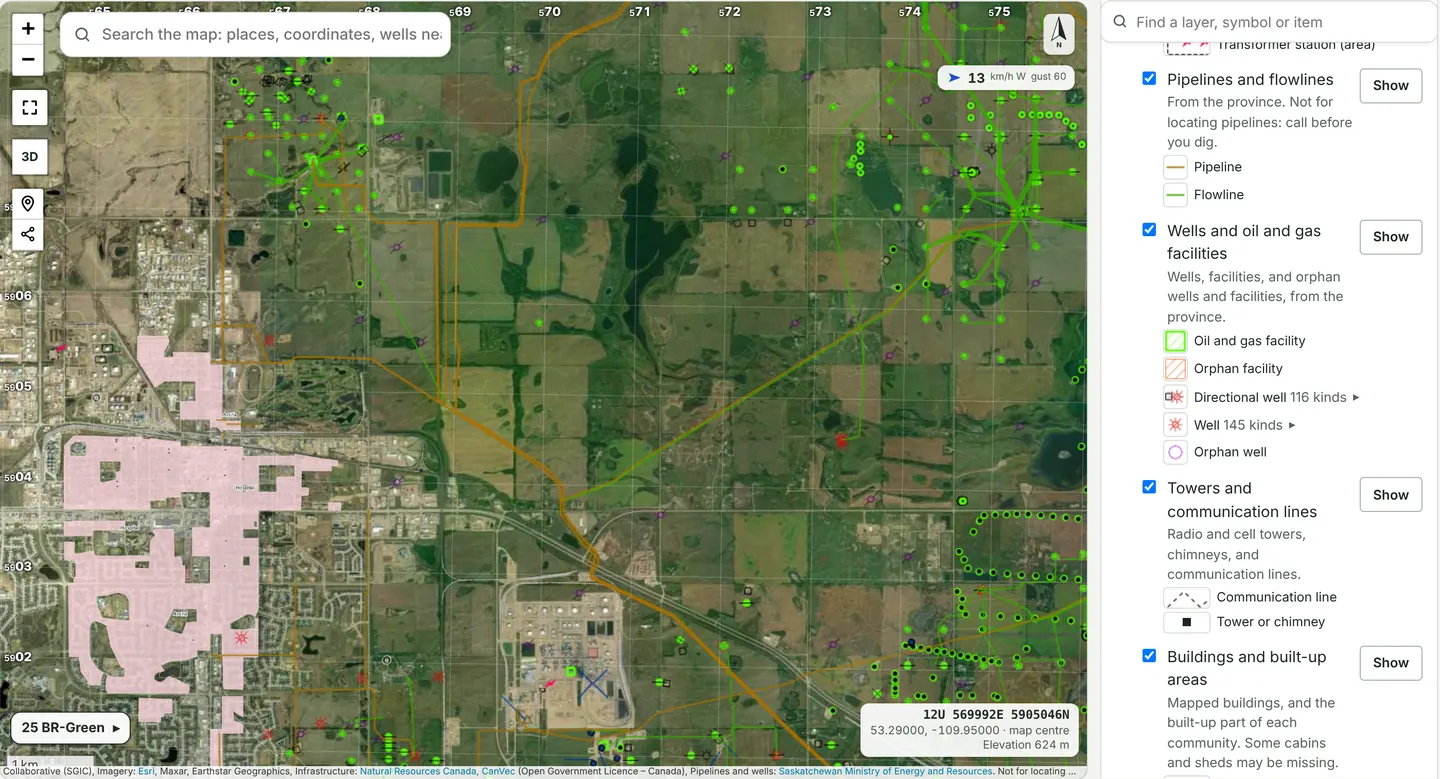
One incident map for everyone on the fire
Command draws the fire, crews add what they build, and everyone sees the same live map on their phone, with no licences to hand out. Tilt it into 3D, or plan the next shift in a private workspace and publish it when it’s ready.
What to protect
- Power lines and substations, pipelines and flowlines, wells and oil and gas facilities, towers, buildings, fuel tanks, water wells and dams, airstrips, railways, and reserves, each with its own colour and key.
- Point at a layer, or tap Show, and everything in it lights up on the map, so you can tell at a glance whether any are there.
- Drag a box, or pick a perimeter or a trigger line, and What’s inside counts the buildings, schools, health facilities, wells, pipelines, and towers in it.
- Search “wells near Beauval” and the map goes there with the wells on.
From Natural Resources Canada and the province’s own maps. Not for locating pipelines: call before you dig.
- Perimeter, heat, guard, hand line, hose lays, helispots, water, and hazards, drawn by Command and added to by the crews who build them.
- Crews, machines, and aircraft live on the map. Out of range, phones keep recording and fill in the track later.
- Satellite imagery with the burned area and its hot edges lit up, official topo with a UTM grid, fuel types, burn history, weather radar, moving wind, lightning, and today’s fire weather and danger.
- Bring in KML, shapefiles, GPX, and infrared flights, then print the fire as big as the wall, numbered to tape together.
Fire behaviour and evacuation
Where the fire could go, and when to get people out.
The enhanced spread forecast grows the fire hour by hour on the national fuel type map, with the day’s burning period, spot fires across water, and slope, always drawn beside the Canadian FBP System alone. Each fire’s evacuation plan then works out, for every community near it, how close the fire can get before it’s time for the alert and the order.
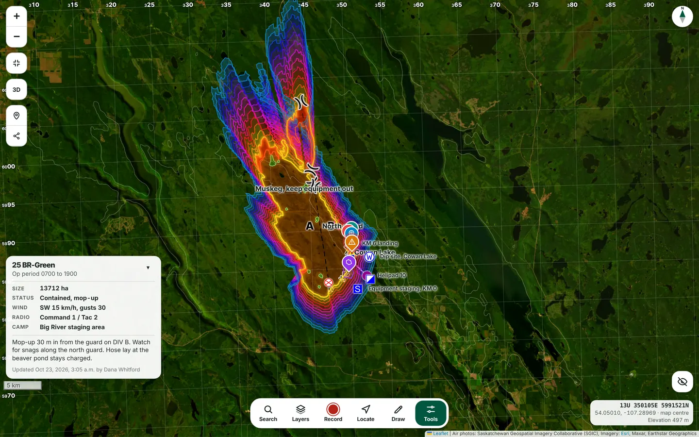
How the forecast works and how it’s checked, in plain terms. The full paper is in the demo.
- The FBP System hour by hour on the real fuels, stopped by lakes and rivers, with noon fire weather and the hourly forecast.
- The enhanced forecast is marked experimental and shown beside the FBP System alone, so you can see what each part changed.
- Trigger lines on the map: how close the fire can get to each community before the alert, and before the order.
- When the fire crosses a line, Firecache raises the alert and then the order to the people named for that community, checked every minute even with every phone closed, and works the lines out again every hour with the newest forecast. Each community’s plan prints with a clear layout.
Spread and arrival times are estimates for Command, labelled as estimates. The enhanced forecast is shown beside the FBP System alone, never instead of it, and the evacuation plan and its trigger lines use the FBP System alone.
Community plans
Communities build their own plans. The agency reviews them. Every fire uses them.
The people who know a community best write its plan: the emergency coordinator, the band or village office, and the fire chief. Firecache fills in everything it can and sends the finished plan to the agency. Once it’s accepted, it’s already in the evacuation plan of every fire that comes near.
- Fills itself in: the 2021 Census figures with one button, a description and photos from Wikipedia with each photo credited, and the fuel within 5 km from the national fuel type map.
- The community adds what only it knows: who needs help to leave, the routes out, the reception centre, how people are warned, and what it can offer a fire camp.
- Sent to the agency, returned with notes or accepted, with every step recorded. A community sees and edits only its own plan.
In the languages people speak at home
Firecache is in English and French today. Plains Cree, Woods Cree, and Dene are coming, starting with evacuation notices, fire updates, and SOS, so elders hear it in their own language.
When the fire comes: evacuees, and the town that takes them in
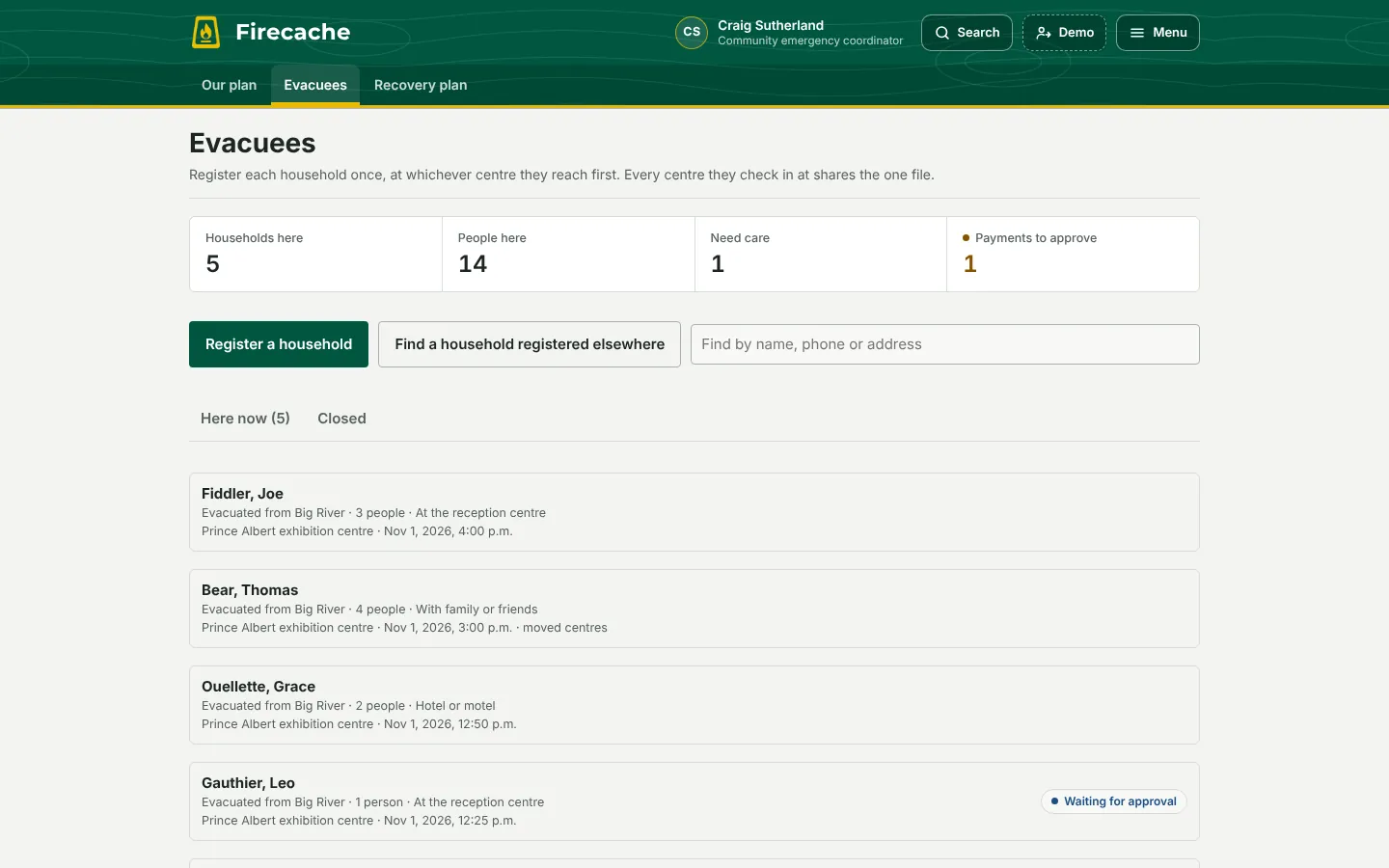
- When the fire crosses a community’s alert or order line, the host community and its reception centre are told how many people are coming and who needs care, as counts, never names.
- Each household registers once, at whichever centre it reaches first, and every centre it checks in at shares the one file, so nobody is registered twice.
- The emergency payment is checked by one person and approved by a second. In the demo it’s a drill: no money is sent.
- After the fire, each community writes its recovery plan from a 12-part template, and the agency reviews it like the evacuation plan.
- Each community has its own home page: what’s happening to it now, its plans, and who to call at the agency.
Command and planning
Start the shift on what could hurt someone.
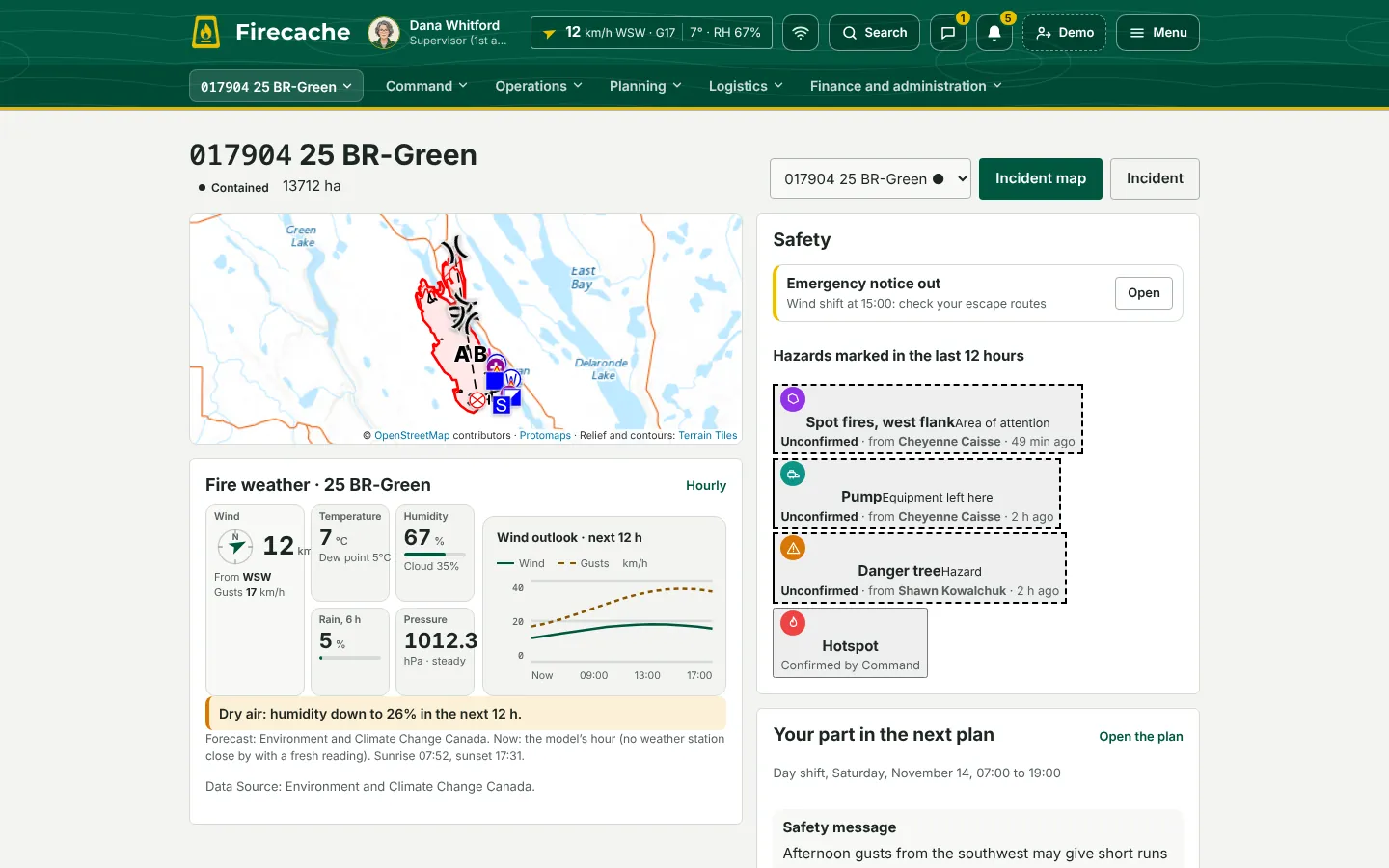
Command opens on one fire at a time, ranked by safety, not by paperwork. The plan, the roster, the forms, and the record of what happened are built from the same records the crews and machines are already sending.
Today
- One fire at a time, ranked by what could hurt someone: man down or SOS, evacuation orders and alerts, emergency notices, and hazards marked in the last 12 hours.
- Your part in the plan: your division, your supervisor, your work and channel, the safety message, and the objectives.
- Since the last plan: what changed on the fire since the last plan went out, and each division’s handover for the next shift, marked received.
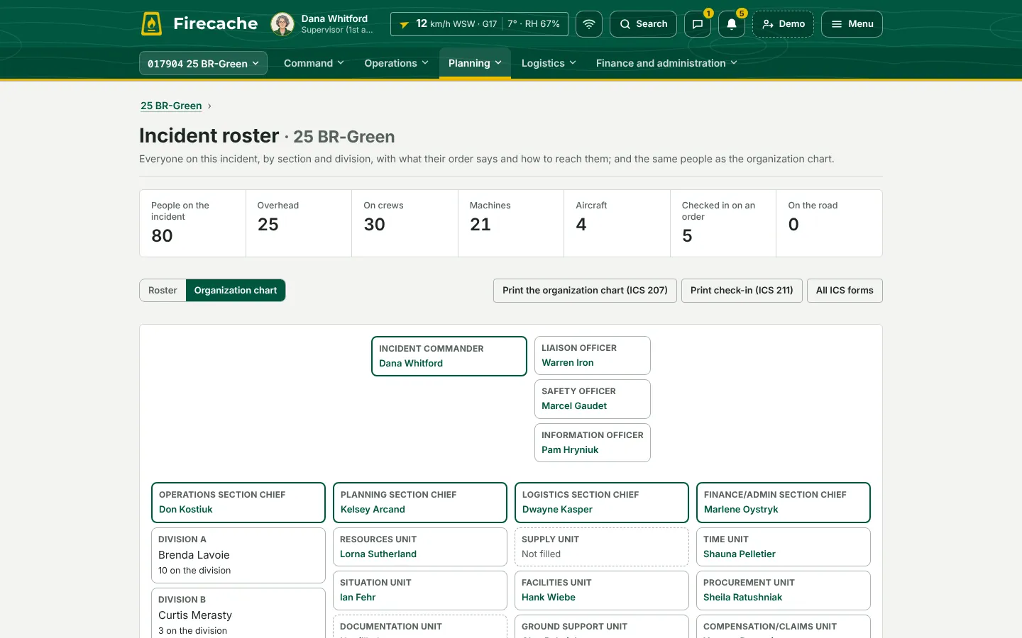
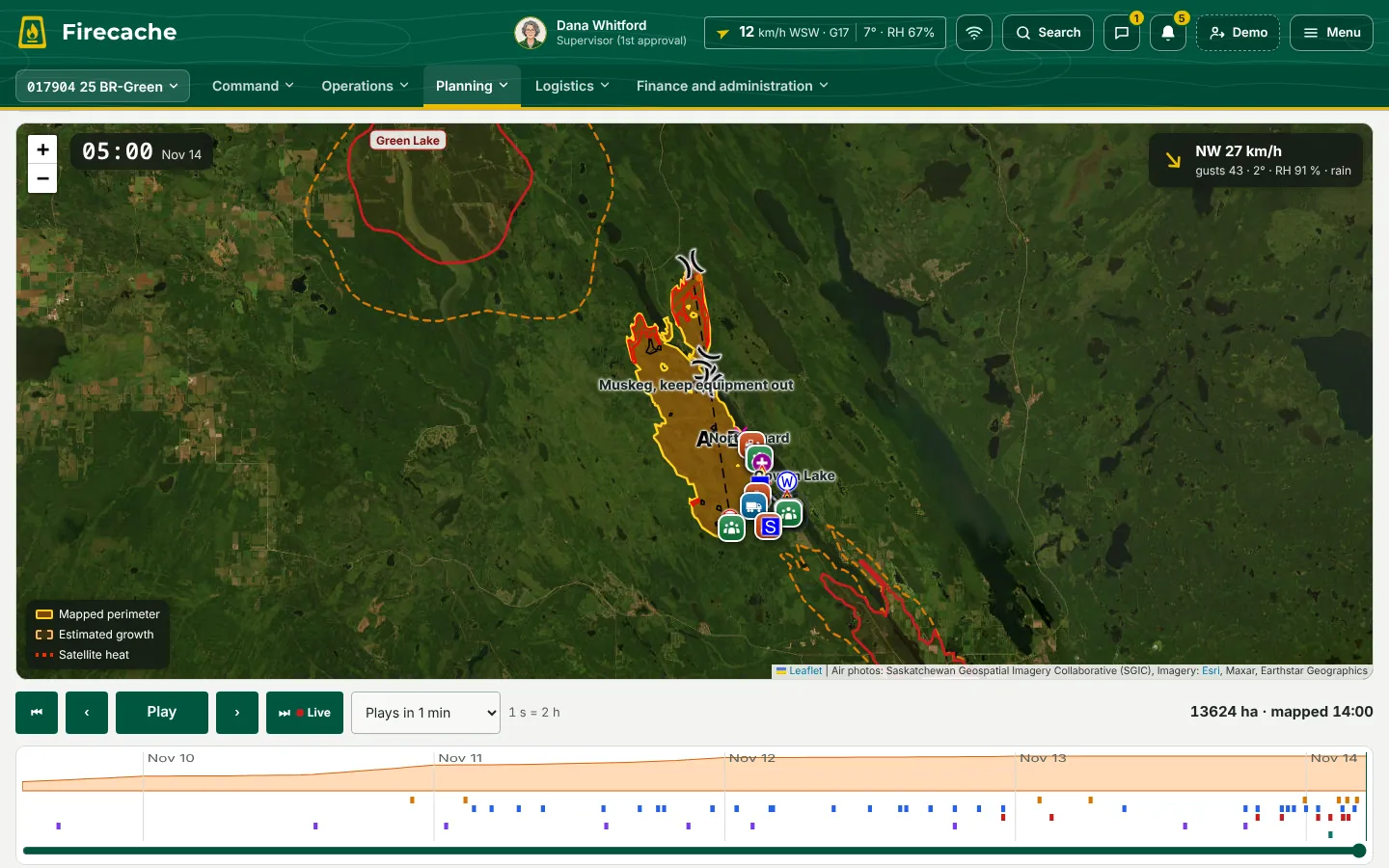
- The incident action plan prints on ICS Canada’s forms, 202 to 220, with the 207 organization chart and the 211 check-in list, filled from what Firecache already knows.
- The roster shows everyone on the fire by section and division, with their resource order, phone, and tickets about to expire.
- Playback replays the perimeter as it was mapped, crews, machines, aircraft, and the wind, with the play by play and how close each unit came to the moving edge.
- A daily situation report across every fire in the province: ranked, issued, amended, and kept.
- Funding requests filled from the fire, with the next few days’ cost forecast, signed in turn up the approval chain.
- Exercises on the real screens: injects to each position, a decision log, and the after-action record with its improvement plan.
Common Operating Picture
Every unit on the fire, and what needs a decision.
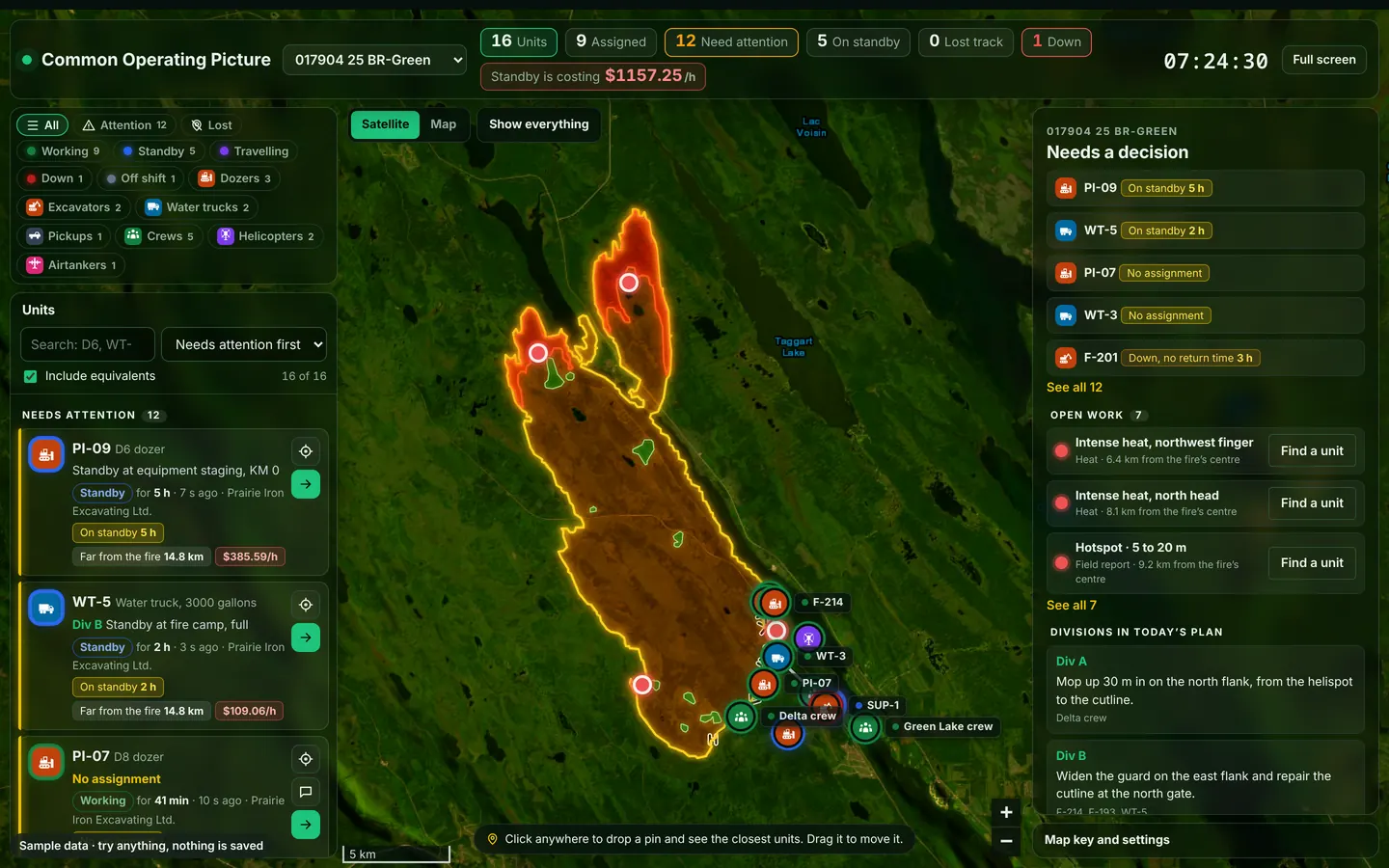
A console for the big screen, the map full size under see-through panels: every unit by type and status on satellite imagery, searchable down to “Cat D6 or equivalent”. Drop a pin to rank the five nearest units by distance and travel time. An attention list catches what slips, each with the nearest open work to send it to, and standby cost is shown by the hour and the day.
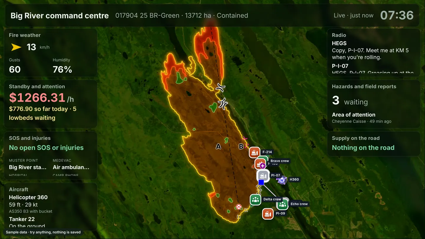
The whole fire, on the wall
- Plug a computer into the command centre TV and sign it in once: the incident map fills the screen, live for everyone in the room.
- Weather, resources, injuries, aircraft, supplies on the road, and the radio sit on it as see-through cards, each placed and sized where Command wants it.
- Notices go to a fire, a division, a kind of unit, or a drawn area. Emergency ones stay on every screen until they’re acknowledged.
- If the connection drops, every screen keeps showing the last data and how old it is.
Air desk
Every aircraft over the fire, on one screen.
Air traffic control for the fire, from any computer: each aircraft over the satellite map with its height, speed, target, and the minutes to its next check-in. Its colour counts down the 30 minutes, the restricted airspace is drawn around the fire, and anything that needs the desk comes up as an alert.
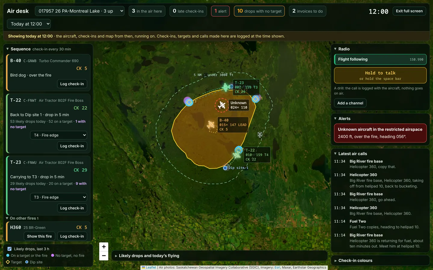
- Check-ins every 30 minutes, with a countdown on each aircraft and a red alert the moment one is late.
- The fire’s restricted airspace, 5 nautical miles out and under 3000 feet, with a warning for any aircraft inside it that isn’t on the fire.
- Likely drops worked out from each aircraft’s track: on a target, on the fire, or neither, and the dips at the water. Crews close to a drop get a warning.
- Flight time invoiced from the transponder, from 2 minutes before the first takeoff to 2 minutes after the last landing, then signed by the desk, the pilot, and the company.
Hazards, field reports, and SOS
See it, send it, and Command has it.
A danger tree on the access road, spot fires over the guard, or someone hurt at the landing. Anyone on the fire can send it in seconds, and the right people know right away.
- Photos record where, when, and which way they were taken. Sent with no signal, a report goes as soon as there’s a connection.
- SOS: hold for three seconds, and your base, the supervisors on your fire, your head office, and the duty officer know where you are. Someone hurt? Raise a man down in a tap, and the medics hear it first. In the demo, it’s a drill.
Radio desk
Every radio call, recorded and transcribed
Firecache records every channel on the fire around the clock and transcribes each call as it comes in. Nobody has to jot times on a notepad, and nothing said on the radio is lost.
- Listen live, or scroll back to any moment and play it again, at up to twice the speed.
- Each call is transcribed word for word, with a suggested update, like a start on a daily, a breakdown, or a medical alert. Nothing changes until someone approves it.
- Flight following: every aircraft from its transponder, with a countdown to its next check-in that turns red when it’s missed.
The demo replays one recorded fire day on four channels: Command 1, Tac 2, the base, and flight following. Live channels need a radio gateway at the base.
Name each frequency, give it a colour, and choose what’s recorded. In the app, you can also add frequencies, set tones, and reorder them.
Messages, notifications, and calling
The right person, in a tap.
Message anyone you work with. The people you need most are pinned at the top for your role, what needs you shows up the moment it comes in, and you can call over Wi-Fi when there’s no cell service.
- One-to-one and group chats with photos and PDFs, read receipts, and a chat on every daily.
- Notifications for each role: a daily to sign, a hazard on your fire, an order on the road.
- Calls over Wi-Fi or the base’s satellite internet, and the agency’s shared phone book with a log of every call.

Fire bases and logistics
Every pump, saw, and truck, labelled and signed for.
Print a label and stick it on. From then on, any phone can scan it to see who has it, where it went, when it’s due back, and what shape it was in.
- QR labels on Avery sheets or label printers, starting partway through a used sheet. Every tag starts with the base: FC-LR for La Ronge.
- Scan with any phone to sign gear out with a due date, its condition, and photos. Stock counts show what’s missing and what doesn’t belong.
- Trucks too: odometer, condition photos, a circle check, and defects with every daily mileage report.
- Order camp and fire equipment in a few taps, then follow it from the cache to the fire. Short lines are offered by the nearest bases with stock to spare.
- 1Requested
- 2Approved
- 3Being picked
- 4On the road
- 5Delivered
Reclamation
Every mark the fight left on the ground, ready for rehab.
Dozer guard, hand line, roads, helispots, staging, camp, water sites, and equipment left behind are all gathered from the incident map as the fire is fought. When it’s out, the reclamation plan is already written.
- Each item with its length or area and its coordinates in latitude and longitude and UTM.
- Fill in the work as it goes, see the plan as it stood on any day, and what changed between two days.
- Satellite imagery of the same ground before and after, side by side.
- Print it, or save and email it as KML, GPX, GeoJSON, or CSV. A copy filled in elsewhere comes back in.
Security
Built to be trusted
Turn parts of Firecache on or off for the agency, one fire, one base, or one person, and the most specific setting wins. Operators never see rates, and a contractor on one fire sees what they need and nothing else.
Hosted where you choose
It’s your data, so it lives where you decide.
A box in your own office, on your own network.
Encrypted
Encrypted in transit and at rest, on phones and on the server.
- In transitTLS on every connection
- On the serverEncrypted at rest
- On phonesThe offline copy is protected by the device
- Sign-inSigned sessions that expire
Every change on the record
A tamper-evident ledger. Not even an administrator can alter it.
Supported by firefighters
Built, run, and supported by firefighters who know the fire season.
- 06:12Base server battery swapped at Cumberland House · 4 min
- 07:48Map tiles slow up north, switched to backup · 6 min
- 09:30New contractor set up for La Ronge · 11 min
- 13:05Label printer added at Buffalo Narrows · 3 min
A sample day. Every call is answered by someone who has worked a fire line.
Hosting, encryption, server-enforced access, monitoring, on-call support, and uptime describe the production version of Firecache. This demonstration runs on test servers, and its access settings are a preview saved on your device.
See it with real roles
The demo has every role, from a gel unit operator to the Time Unit. A guided walkthrough follows one daily from the field to payment, one person at a time, and you can switch to anyone with a single tap.
Fire season 2027
The 2027 fire season is coming. Be ready for it.
Setting Firecache up for your agency, bringing in your contractors, rates, and bases, training your people, and testing it in the field all take time. Register your interest now and we’ll plan your build around spring.
Talk to us
Request access
Tell us a little about you and what you’d like to see, or register your agency’s interest for the 2027 season, and Andy will be in touch.
What happens next
- One of our founders will reach out to you personally.
- A walkthrough on your kind of fire.Your bases, your contractors, your forms. Bring the people who’d use it.
- A build made for your agency.Your forms, rates, bases, and rules, in English and French. It isn’t a subscription.
- Ready before the season.Set up, tested with your people, and supported all season by firefighters.
Keep track of Firecache development
Subscribe to receive Firecache updates by email: what’s new as the app develops. Unsubscribe any time.
From Firecache. We’ll email you a link to confirm first. You can withdraw your consent at any time.
Sender details
This is a demonstration, not an official government system, and nothing in it is real. The people, companies, fires, equipment, aircraft, rates, records, messages, and radio traffic are made up, and any resemblance to real people or companies is purely coincidental. Forms and documents are modelled on publicly available examples; they are not any agency’s official forms, records, or data. Screens and samples on this page show the demonstration. Questions: demo@firecache.ca · 368-380-1262.